Council on Energy, Environment and Water Integrated | International | Independent
Suggested citation: TNGCC and CEEW. 2026. Toward Climate-resilient River Systems in Chennai: Assessing Risks at the Sub-basin Level and Advancing a Circular Economy Approach. New Delhi, India: Tamil Nadu Green Climate Company; Environment, Climate Change and Forests Department, Government of Tamil Nadu; and Council on Energy, Environment and Water.
The Tamil Nadu portion of the Chennai river basin, spanning five districts and contributing nearly 33 per cent to the state’s economy, is experiencing rising frequency and intensity of climate extremes and mounting pressures on water quantity and quality. Comprehensive climate risk assessments and understanding the changes in water balance under different policy scenarios are necessary to ensure climate resilience and water security, and thus economic growth and sustainable development in the state.
This study, undertaken in partnership with the Tamil Nadu Green Climate Company (TNGCC), estimates the climate risk index and the top contributing indicators to risk to water resources for each of the six sub-basins using the Fifth Assessment Report (AR5) framework of the Intergovernmental Panel on Climate Change (IPCC). It also estimates future water demand and availability for each sub-basin under six policy scenarios, including joint uptake of micro-irrigation with treated used water reuse (with and without climate change considerations) as one of them.
Eleven of India’s 15 major river basins in India are at least water-stressed (Bassi et al. 2023), and a quarter of groundwater aquifers are being used beyond safe extraction limits (CGWB 2024). Further, most river basins in India are highly vulnerable to climate extremes; as a result, 600 million people in the country face extreme water scarcity (NITI Aayog 2018).
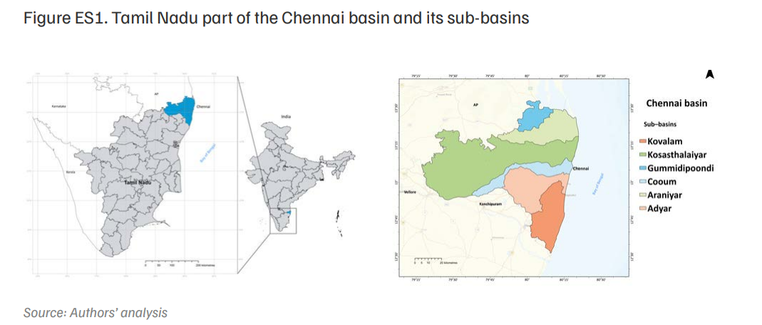
This study focuses on the Chennai basin, the majority of which (about 78 per cent) lies in the state of Tamil Nadu (CCCDM 2022), spanning five districts – Chennai, Chengalpattu, Kanchipuram, Ranipet, and Thiruvallur – which together contribute about 33 per cent to the state economy (DES 2024a). Within Tamil Nadu, the Chennai basin comprises six sub-basins – Adyar, Araniyar, Cooum, Gummidipoondi, Kovalam, and Kosasthalaiyar (Figure ES1).
The districts within the Chennai basin recorded a rise in short-duration, high-intensity rainfall events during both the south-west monsoon (SWM) (June–September) and the north-east monsoon (NEM) (October–December) in 2011–22 compared to 1981–2011 (Prabhu and Chitale 2024). Climate change has also increased the intensity and duration of cyclones in the Bay of Bengal over recent decades (Selva et al. 2025). Additionally, the basin is experiencing a surge in droughts and floods and faces a rising risk of future droughts (Anandharuban and Elango 2021; CCCDM 2022; Joseph 2022; Kaaviya and Devadas 2021).
Rapid urban expansion has further intensified water stress in the basin, predominantly through the loss of water bodies, including traditional tank systems that historically sustained irrigation and domestic water demand (Rajagopalan et al. 2024). Urbanisation has led to the loss of 13.6 million cubic metres (MCM) of tank storage within Chennai city, while an additional 175 MCM of tank storage outside the city is now at risk (Devi et al. 2025). At the same time, sewage treatment capacity in the region has become overwhelmed, leading to the discharge of untreated used water into rivers and the subsequent deterioration of both surface water and groundwater quality (Ramachandran et al. 2021; Rosado et al. 2024). The increasing frequency and severity of climate extremes, along with challenges to water quantity and quality, call for urgent action to build climate resilience in the Chennai basin. Assessing climate risk, including physical, social, economic, institutional, and policy factors, is the first step. Further, assessing the current and projected water balance in the basin, i.e., the difference between the water supply requirement and the water actually supplied, is crucial for enhancing water security and hence reducing the risks posed by climate-induced extremes. Such assessments can inform adaptation measures such as adopting a circular economy approach to water management and improving water use efficiency. Further, interventions informed by water risk assessments in the Chennai basin can support 36 targets under 11 Sustainable Development Goals (SDGs) (Figure ES2).
Figure ES2. Potential SDG targets that the state can attain from interdisciplinary climateinduced water risk assessments
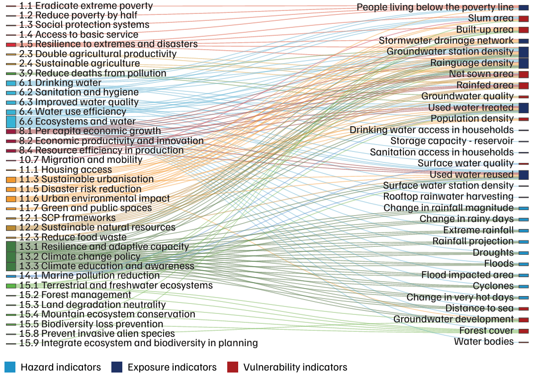
Source: Authors’ analysis based on Guppy, Lisa, Paula Uyttendaele, Karen G. Villholth, and Vladimir Smakhtin. 2018. “Groundwater and Sustainable Development Goals: Analysis of Interlinkages.” Hamilton, Canada: United Nations University Institute for Water, Environment and Health and UN-Water. 2016. “Water and Sanitation Interlinkages across the 2030 Agenda for Sustainable Development.” Nairobi, Kenya: United Nations Environment Programme. Note: SCP - Sustainable Consumption and Production
Objectives of the study
We conduct the analysis at the sub-basin level. The study has the following three objectives:
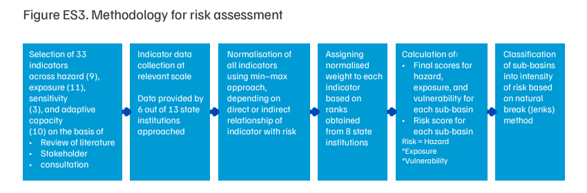
The methodology for Objective I is entailed in Figure ES3.
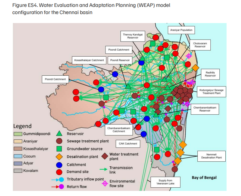
To address Objectives II and III, we used the Water Evaluation and Adaptation Planning (WEAP) model to assess the water balance of the Chennai basin (1994–2050) under various climate, population, and TUW reuse scenarios. The model was configured for the six sub-basins of the Chennai basin and integrated data on rainfall, evapotranspiration, groundwater, reservoirs, and demand from domestic, agricultural, livestock, and industrial sectors (Figure ES4). Inputs were sourced from national and state agencies, and climate projections were based on the Representative Concentration Pathways (RCP) 4.5 scenario. The outputs were statistically bias corrected and downscaled to a spatial resolution of 25 kilometres (km). Following are the six scenarios developed to evaluate future water demand and availability:
Sections below present the key findings from the risk assessment and WEAP modelling exercise.
Risk assessment
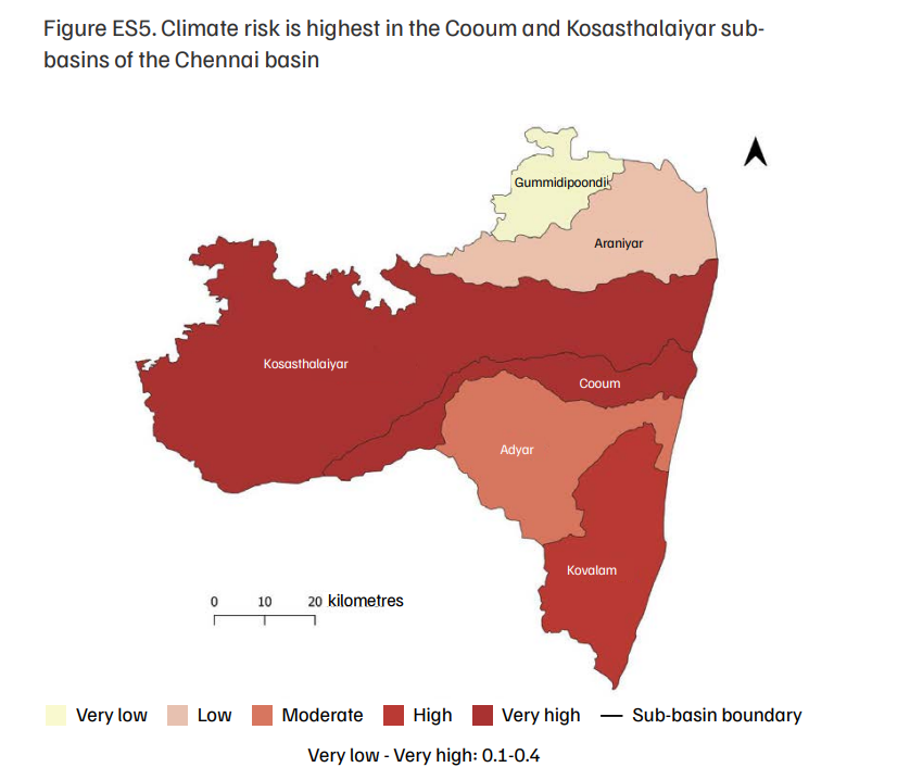
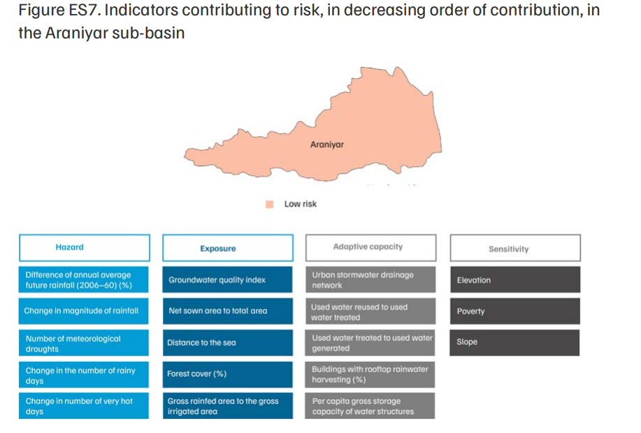
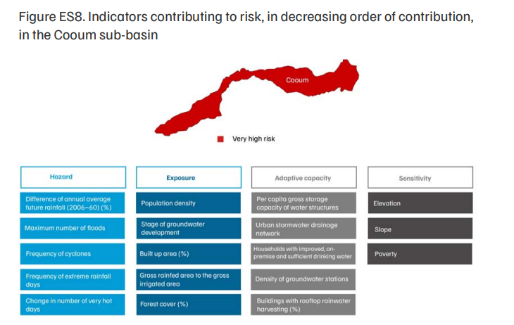
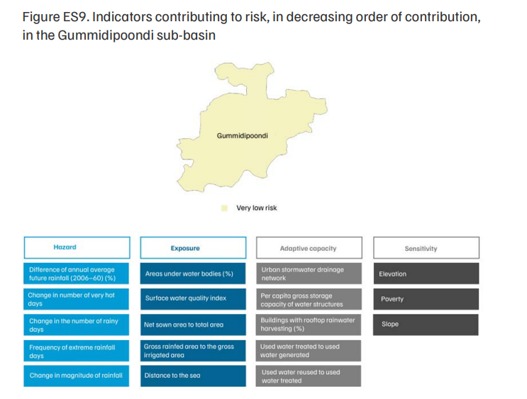
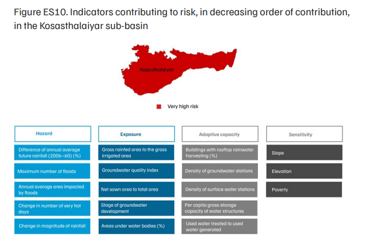
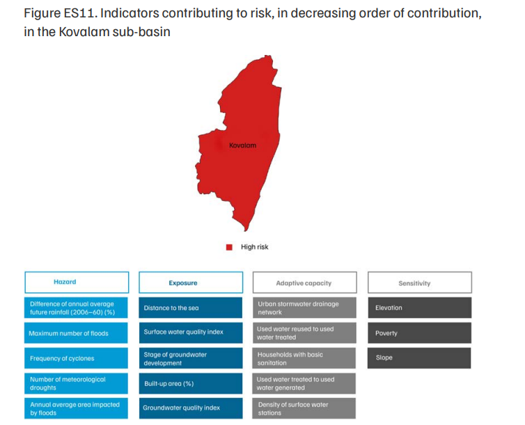
The risk to water resources in each sub-basin from the changing climate, calculated as a product of that sub-basin’s hazard, exposure, and vulnerability, is presented in Figure ES5. Among the sub-basins in the region, Cooum and Kosasthalaiyar exhibit the highest risk levels, followed by Kovalam, Adyar, Araniyar, and Gummidipoondi. These ranks are comparative; a lower rank should not be interpreted as a dissolution of the need for climate action.
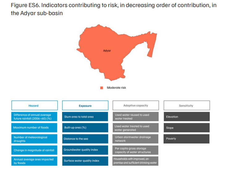
Figures ES6–ES11 present the top five contributing indicators for each risk subcomponent. Since sensitivity had only three indicators, all three were deemed important. Overall, the indicators have been presented in descending order of their contribution to hazard, exposure, sensitivity, and adaptive capacity.
Water balance
The following recommendations aim to reduce water risk and deficits in the Chennai basin and are considered feasible for implementation over the next five years:
Together, these recommendations provide a clear direction for action in the near and medium term, supporting more resilient water systems under a changing climate in the Chennai basin.
The study identifies sub-basin-level climate risk to water resources in the Tamil Nadu part of the Chennai River basin and simulates future water demand and supply under six policy scenarios. The findings from the study can support 13 state institutions of the government of Tamil Nadu in effective, climate-resilient water resource planning by prioritising budgets and implementing targeted adaptive measures, especially the reuse of treated used water and micro-irrigation.
Risk is the potential for adverse consequences for human and ecological systems, including impacts on lives, livelihoods, infrastructure, and ecosystems. Risk arises from the interaction among hazard, exposure, and vulnerability, comprising sensitivity and adaptive capacity.
The WEAP tool is an integrated, scenario-based modelling platform designed to support water resources planning and management. This model, developed by the Stockholm Environment Institute, uses a mass-balance approach to simulate the allocation of water from various sources across competing demand sites.
As per the Brisbane Declaration, 2007, e-flow is defined as the quantity, timing, and quality of water flows necessary to sustain freshwater and estuarine ecosystems and the human livelihoods and well-being that depend on them. Assessing e-flow is crucial for maintaining ecosystem health, as it helps understand and manage ecological requirements.
The Indian Subcontinent and the Water CycleFrom Monsoon to Ocean
Water, Nature, Progress: Solutions for a New India
India and the GulfA New Strategy for Water, Energy, Food, and Ecosystem Security
Scaling Climate-smart Micro-irrigation in Gujarat